Blog written by team: Black-faced spoonbill (Platalea minor)
Team members: Lu Bai (Waterloo), Yuan Liu (Queens) and Arielle Vary-O’Neal (Ottawa)
Weather: Hot and cloudy, with an average of 30˚C
小组:黑脸琵鹭
团队成员:白露(滑铁卢大学),柳源(女王大学),Arielle(渥太华大学)
天气:多云, 日均温度:30摄氏度
Today was a very long day, but very fulfilling. We went to the shores of Gong Hu Lake in Wuxi, a reconstructed wetland funded by government monies, to begin a a class project on wetland assessment. The Gong Hu Lake project began in early 2000 and today, in 2018, is in Phase IV – comprised of monitoring its success, maintenance and assessing how it might ultimately attain some independence from continued need for inputs. Our assessment project will later give us some general idea of the success of this final project phase.
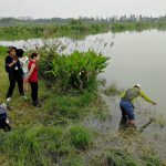
We immediately went to work after learning of our sampling site – the afternoon proved to be very hot! The physical assessment of our site was the first thing on our list: the angle of the slope, aspect (compass direction of the slope), percentage of water covered by macrophytes, percentage of canopy covering the site. Dr. Lougheed, armed with binoculars, later came to our site to help us count and identify the bird species. For 15 minutes, we scanned the sky and the trees and ended up identifying 6 species, including the Long-tailed shrike (Lanius schach) and the Light-vented Bulbul (Pycnonotus sinensis). We even saw a family of Little Grebes (Tachybaptus ruficollis), with two adults and two juveniles. This is an excellent sign, as this means birds are able to successfully reproduce here. Even before taking further assessment measures, we already knew that Gong Hu was going in the right direction – the presence of birds and their great diversity we thought an excellent indicator of a healthy ecosystem.
Walking on the causeway after lunch, we were struck by how much the appearance of Gong Hu was different from that of Tai Lake, though only divided by a few meters of concrete. Gong Hu water seemed crystalline in comparison, while detritus and cyanobacteria floated on the surface of Tai Hu. But we remain optimistic! Gong Hu’s efforts seem to be working, and we have hope that the same efforts and dedication will one day be applied to all of Tai Lake.
After these initial activities, we performed a benthic biodiversity analysis using an Eckman grabber. The only organisms we identified were gastropods. We hypothesized that the sediment, mainly comprised of very fine mud and dark clay, was anaerobic and unfit for supporting many species.
Our final assessment included measuring water chemistry attributes including pH, dissolved oxygen, salinity, conductivity and turbidity. As we were performing these tasks, a local family seemed really interested in what we were doing. They stepped right in and watched us very closely, as we tried to explain the project to them. After we finished collecting water chemistry parameters, Bobo drove us back to the coffee shop to meet up with the rest of the group for watching Unmanned arerial vehicle (UAV) demonstration. We were stunned by the ‘show.’ The UAV can go up to 100 meters high and take picture every 3 seconds for the entire field of view (transmitted to the tablet so we see it in real time), is used for monitoring environmental changes.
Today definitely provided much to reflect upon. Tired but satisfied, we returned to the hotel. Another equally busy day awaits us tomorrow!
充实又漫长的一天又开始啦。我们今天依旧来到了位于无锡市的贡湖湾,在湖的不同位点进行水质检测. 始于2000年的贡湖项目现如今处于四期-着重于维持生态系统可持续发展。贡湖湾项目是湿地修复重建的一个成功典例.
到达取样点后,我们立即开始测量取样点的相关地势参数:坡度,水中的植被覆盖率,树荫遮盖率等。接着罗汉德教授带着望远镜来帮助我们统计取样点鸟类的种类及个体数. 我们用了15分钟来扫视天空与树木并在最终观测到包含鷿鷉和白头鹎在内的6种鸟类. 我们在进行水质检测前就了解到贡湖水质已然提高,但是鸟类多样性的存在进一步验证了生态系统的优化和改善.
午饭后,我们走上堤道再次去往取样点的途中对仅有一桥相隔的贡湖及太湖的水质相差之悬殊所震惊. 相比之下,贡湖的水清晰透彻而太湖的水面却浮着很多垃圾与蓝藻. 但是我们相信在看到贡湖湾项目取得的成果后,相关部门最终也会解决太湖的污染问题!
接着,我们用Eckman采集器进行了底栖动物生物多样性分析,然而我们只观察了到腹足类动物。我们猜想这是因为我们采集的沉积物样本主要由细泥和深色黏土组成,形成一种不适有氧生物存活的无氧环境。
最终,我们测量了包含酸碱度,溶解氧,盐度,电导率以及浊度在内的水化学参数。在测量过程中,一家当地居民似乎对我们正在进行的工作很感兴趣,并且在我们试图向他们解释我们的工作内容时踏入我们的工作区观察我们。结束水化学参数的采集后,波波将我们载往邻近的咖啡厅与其他小组会和观看无人机运作展示。最高可飞升至离地100米的高空并且每3秒拍摄一张陆地照片的无人机被用来检测环境变化情况。大家都为UAV的强大功能所震惊!
劳累但收获满满的我们在今天学到了很多新的知识技能后返回酒店。繁忙的另一天在等着我们!
-
- Dr. Wang measuring water conductivity at Group 1’s site.
-
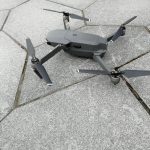
- Unmanned arerial vehicle (UAV), model MAVIC Pro.
-
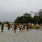
- The flying team demonstrating the UAV to our students.
-
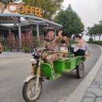
- Tour guide ‘Bobo’ driving students to their sites on the electric tricycle.
-
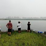
- Bird watching with Dr. Lougheed in the morning with Groups 3
Leave a Reply